
mobile 2 : jane foster : the traveling circus
Showing posts with label canberra. Show all posts
Showing posts with label canberra. Show all posts
Monday, 17 October 2011


Friday, 14 October 2011
10 : Reflection
Even though I still have a lot to do, I am feeling a little more confident. I did at least one thing everyday this week, which kept my mind thinking about the project, which deterred me from getting distracted. I still would like to do a big 24 hour needs-analysis of the dedicated train route in a similar style of what I did for a project last year - I think I will ask Jane, if it is worth me spending the time.

My parliamentary justification so far is:
Realistically, politicians will probably not need to travel to Canberra for parliament as often, mostly due to technology advancements - so I will focus on servicing the people of Canberra, the greatest good for the greatest number of people -- (Jeremy Bentham, Enlightenment Principle)
Tuesday, 11 October 2011
10 : Reading : Transport for Suburbia
My intelligent, urban designer friend from Melbourne, recommended this book Transport For Suburbia - Beyond the Automobile Age, by Paul Mees, as it compares and discusses suburban transport systems in a variety of international cities (including Canberra).

The Canberra plan had one overriding objective, to eliminate traffic congestion. This was to be achieved by restricting employment in the city and centre and providing an extensive network of freeways. Canberra was laid out as a Y-shaped ‘linear city’ ... and one intended to allow a ‘balanced’ transport system incorporating a bus rapid transit connection between major centres. The proposed busway was never built, but most of the freeways were, and Canberra has become a paradigm of autopia, albeit one with an urban form that would make it feasible to retro-fit a public transport system. (Mees, 2010, Page 44).
Monday, 10 October 2011
10 : Development : Possible Route
Using the existing infrastructure maps, with overlays of the low socio-economic areas, I have shown very simply the answers to my questions:
- Where do the people who rely to public transport live?
- Where are these people going?
- Other places of interest / extensions of the line.
Maybe this is just the architect in me, but I the shades of grey are much nicer and less harsh then all that colour from earlier today.

I will attempt to settle on a distinctive route tomorrow so that I can begin developing the light rail in more detail. I still need a solid brief and imagery by Friday!!
Also, I need to reminding myself than just providing a light rail is not enough... it is only one form of mobility, and it is not a architectural entity either. Perhaps I will refer back to my 'visual thesaurus' I created a few weeks ago for inspiration on how the contents of my light rail can also reinforce the 'mobile' idea.
10 : Research : Existing Public Transport
Below is a couple of map overlays with the existing key bus routes and bicycle pathways, that the light rail will possibly 'support' and then maybe eventually (one day) replace. This will be used towards my justification as to where my light rail system should be situation.


10 : Development : Maps
Using the data in the research article (which was originally complied in SEIFA) I have developed mappings which show the suburbs which are considered to be generally deprived.


These maps illustrate that the most deprived areas are Acton and Charnwood which are both located North of Lake Burley Griffin. Acton is covered mostly by the Australian National University which may explain is low rating. Charnwood is located in the Belconnen district, and was designed using the Radburn town planning principle (houses face a common parkland) which failed due to residents building fences
There is also high density of the band 3 deprivation in the southern district of Tuggeranong. It is the second largest district outside of Canberra, and is considered a 'growth area' in terms of its new facilities such as the large Tuggeranong Shopping Centre, Arts Centre and the Town Centre.
I will use this information to develop a possible route from the Northern Districts, to the Southern Districts... of course, keeping in mind the existing infrastructure in each area.
10 : Reading : Socio-Economic Areas
I have been trying to compile the information I need to create a map which highlights the areas which will be the most advantaged by a light rail network (for example, places which will require it to get them to from work/school etc if the using private transport was too expensive).
SEIFA: Socio-Economic Indexes for Areas
This has loads of data, but with all the numbers it is difficult to sift through - I think I will focus on finding research papers which have already used this data in relation to Canberra (I figure this will be the most time-efficient approach).
Suburban scars: Australian cities and socio-economic deprivation
This article by Scott Baum, from Griffith University, uses SEIFA data to create a General Deprivation Index.
I know that paying some extra special attention to these maps now, can mean some great 'last minute' additions in the final presentation.
SEIFA: Socio-Economic Indexes for Areas
This has loads of data, but with all the numbers it is difficult to sift through - I think I will focus on finding research papers which have already used this data in relation to Canberra (I figure this will be the most time-efficient approach).
Suburban scars: Australian cities and socio-economic deprivation
This article by Scott Baum, from Griffith University, uses SEIFA data to create a General Deprivation Index.
Canberra is largely considered as a public service town which usually translate into generally less deprived suburbs. The regional concentration ratio of Canberra shows relative deprivation to be low. In particular there are very few suburbs with even moderately high deprivation (the exception being Acton, the suburb largely containing the Australian National University). (Baum, 2008, page 27).I have obtained the list of all the suburbs from the appendix of this article and will now use this to create a few pretty little mappings.
I know that paying some extra special attention to these maps now, can mean some great 'last minute' additions in the final presentation.
Saturday, 8 October 2011
10 : Research : Existing Infrastructure
I found a great website today which displays the current bike and walk routes in Canberra and in the outer suburbs, might come in useful when trying to link existing infrastructure to the new.


Wednesday, 21 September 2011
08 : Research : Canberra Events
I trawlled through as many websites as I could find with different events and put together a table like this:

I then converted this into a map to see if there was some sort of distinctive movement pattern over months.


One random thing I discovered was that Canberra has special events just for people who have arrived in Canberra in the last twelves months. Here is advertisement below:


I then converted this into a map to see if there was some sort of distinctive movement pattern over months.


One random thing I discovered was that Canberra has special events just for people who have arrived in Canberra in the last twelves months. Here is advertisement below:

Thursday, 8 September 2011
06 : Research
I'm looking forward to having a bit of a chat to Jane about which direction to take for the rest of the semester.
One idea I had was to focus on the integration of 'Russell' into the master plan, as with our new transport plan this would be the 'gateway' into Canberra, the first glimpse into the axis of the city.
Russell is one of the smallest suburbs in Canberra, comprising a number of government offices but no private residences. It is probably best known for the headquarters of the Australian Defence Force, which is housed in the Russell Offices complex.
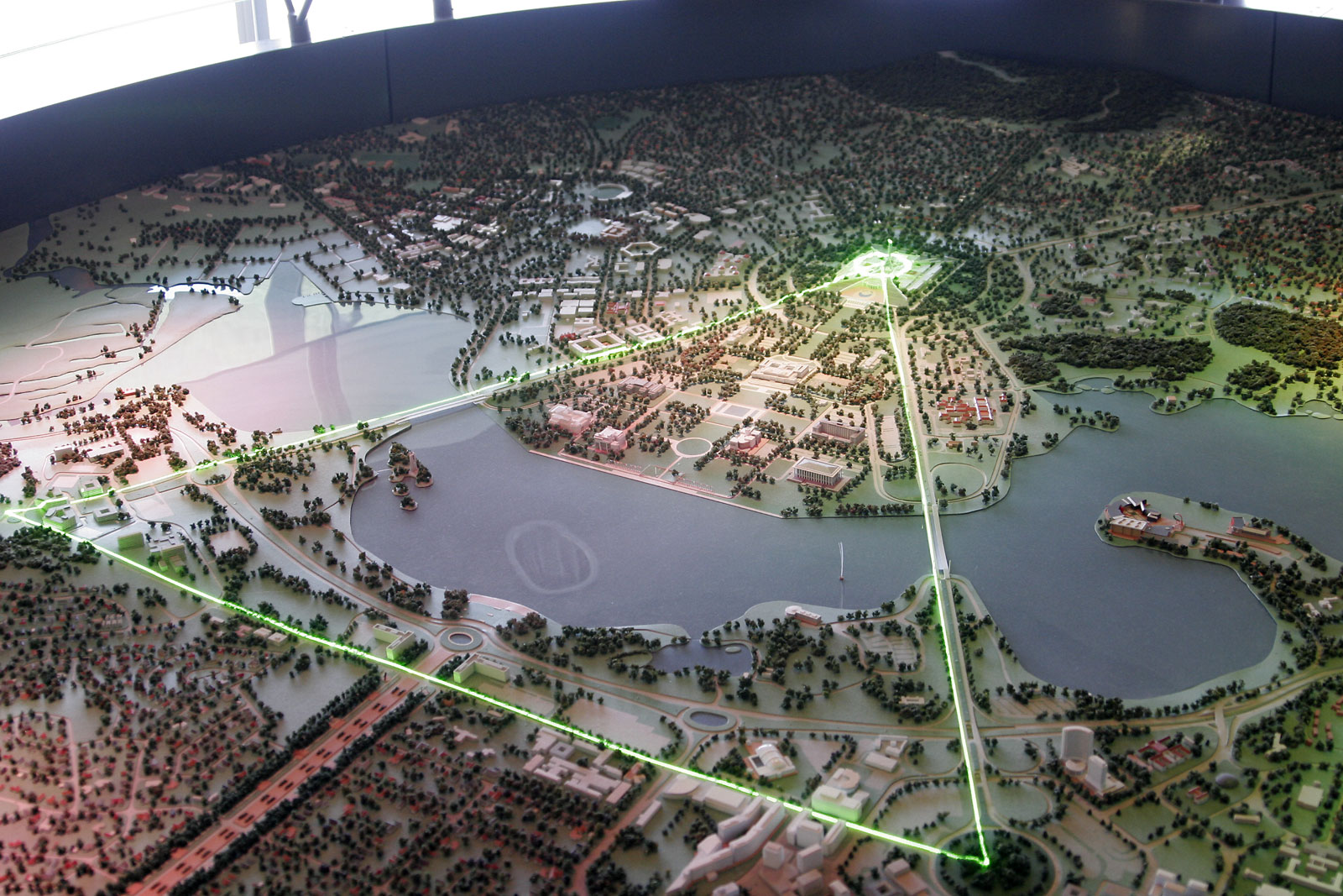 |
| The Parliamentary Triangle is the ceremonial precinct of Canberra, containing some of Australia's most significant buildings. The triangle is formed by Commonwealth, Kings and Constitution avenues. |
 |
| Russell Offices complex comprise the Office of National Assessments and Australian Security Intelligence Organisation, as well as the Department of Defense and Australian National Defense Force. |
 |
| View of Campbell Park, headquarters of the Australian National Defense Force. |
 |
| From the book 'Canberra Following Griffin' the diagram illustrates a study for National Capital Authority, about the 'Central National Area' completing the Constitution Avenue restoring the Russell corner of the triangle as the new entry to the city. |
 |
| The Australian–American Memorial commemorates the role of the United States in World War II. |
06 : Individual Assignment
As I understand, the purpose for the rest of the assignment, is build upon the 'strategy' at our interim presentation and create an architectural entity which is to replace and/or support one of more specific function the parliament house currently provide.
Slightly confusing... but upon reflection of our strategy, I've tried to break this down into some sort of concept to give me a bit of direction for the rest of semester.

Slightly confusing... but upon reflection of our strategy, I've tried to break this down into some sort of concept to give me a bit of direction for the rest of semester.

Thursday, 1 September 2011


05 : Interim : Mapping
The nolli of existing Canberra is to be situated in the bottom right hand corner. I played around with different layers, in order to illustrate how vast the area is:
 |
| 01 - base map from nearmap.com |
 |
| 02 - green areas |
 | |
| 03 - water areas |
 |
| 04 - built areas |
 | |
| 05 - combined maps |
 |
| 06 - final map. the green was too strong on the panel, and not effective. |
Sunday, 28 August 2011
05 : Progress
Brain-wave..... what if Australia was separated into individual countries...
... small distances to manage
... union similar to European Union
... increased densification
only 6 days until presentation... this isn't the best time to have new ideas!!! - but I'll talk to my group about it and see, who knows - maybe it can be incorporated. This is just a really really rough sketch that I did when I first thought of the idea...
 I'll wait and see what the overall plan for the panels is, based on what was discussed in the tutorial and decide if it's worth exploring this idea a little further.
At this stage, I think it's slightly realistic.. and I think that keeping Canberra as a central 'iconic' city. Each of the other capital cities would be given more power to make decisions that affect it's area. This allows the Australian Union in Canberra to focus on bigger, wider issues and the overall well-being of the continent.
... small distances to manage
... union similar to European Union
... increased densification
only 6 days until presentation... this isn't the best time to have new ideas!!! - but I'll talk to my group about it and see, who knows - maybe it can be incorporated. This is just a really really rough sketch that I did when I first thought of the idea...

At this stage, I think it's slightly realistic.. and I think that keeping Canberra as a central 'iconic' city. Each of the other capital cities would be given more power to make decisions that affect it's area. This allows the Australian Union in Canberra to focus on bigger, wider issues and the overall well-being of the continent.
Thursday, 25 August 2011
04 : Research : Statistics
I found a document which has lots of Canberra Statistics. It can be found by following the link here: http://www.cmd.act.gov.au/__data/assets/pdf_file/0016/154501/canberra-quickstats-2009-10.pdf
04 : Research : Canberra
I also looked into comparing it to other Australia cities, in terms of the scale of the blocks etc, if it turns out that this is an important part, I might pretty this up for the presentation. When you see it like this, I actually had to check to make sure I had it all at the same scale.
 |
| Canberra, Australia. |
 |
| Brisbane, Australia. |
 |
| Vienna, Austria. |
 |
| London, England. |
 |
| Melbourne, Australia. |
04 : Progress : Site Analysis
We finally got a chance to meet and discuss everything today:
-- new rail to increase mobility around Canberra.
-- increase density to allow smaller, self-sustainable areas to thrive.
-- make it an example for other Australian cities... a "gateway" into the country.
What's worrying me, is trying to figure out how the parliamentary system will work in the future within this new 'example' city.
After the meeting I printed a base map of Canberra and did some site analysis overlays to assist us in the location of these new stations:
 |
| Road Network |
 |
| Green Spaces |
 |
| River Network |
 | |
| Places of Interest |
 |
| Existing Precincts |
Subscribe to:
Comments (Atom)