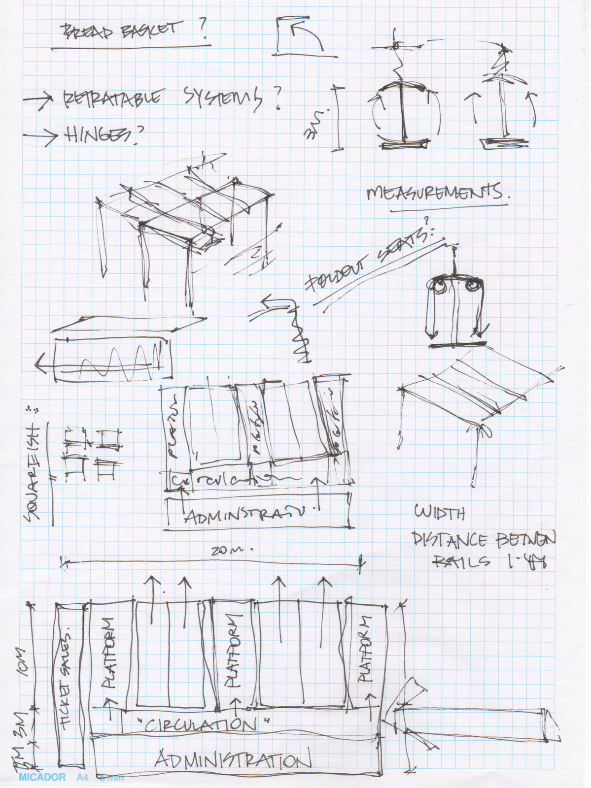
Showing posts with label urban design. Show all posts
Sunday, 30 October 2011
Thursday, 27 October 2011
Tuesday, 18 October 2011
11 : Exemplar : A New Infrasturcture
Some of my favourite images / projects are displayed below:
1) Glocalizing Los Angeles : The physical separations between places of work and play have become outdated and burdensome. Meanwhile the divide between commercial, residential, agricultural, and manufacturing zones have become so exaggerated that the infrastructures needed to connect and sustain them crumble in lack of upkeep and congestion.
2) Modular Diffusion : In a car, the passenger can go from any given point to another in one continuous trip. To achieve this level of mobility in tandem with an increase in roadway capacity, we introduce a mass transit system based upon a Modular Transit Vehicle (MTV for short). This modular system would allow passengers to (1) board from a wide range of street stops, (2) travel along the freeway, and (3) take the freeway exit closest to the destination drop passengers off there, all in one ride.
3) Interstate 10 :
4)
Thursday, 13 October 2011
10 : Research : Loop City by Big
Labels:
analysis,
construction,
diagrams,
exemplar,
mobile,
travel,
urban design
10 : Research : Loop City by BIG
I've always loved BIG Architects, they have an amazing style, particularly in their graphics and presentation of complex information. They tend to really love creating videos also, which is what drew me to this project called 'LOOP CITY' with was developed for the 2010 Venice Bienale.
LOOP City is a master plan for the suburbs of Copenhagen, Denmark centered around an expansive new light rail system that instead of just being a way for people to get around, will actually act as a catalyst to develop the surrounding communities. Conceived by BIG Architects, the transportation loop will feature an undulating rail line with peaks at each station. In addition to acting as "an artery of true urbanity, pumping life into the heart of the suburbs," the project will also incorporate strategies for energy efficiency, waste management, and water treatmentInstead of just providing transportation for the area, the loop will harbor development for the cross border region, allowing different programs to grow around the new stations. ”At certain points the rail becomes a building itself almost like a Roman aqueduct passing through the suburbs,” says BIG of the project. “At other points it forms small pockets of urbanity around the stations.”

LOOP City is a master plan for the suburbs of Copenhagen, Denmark centered around an expansive new light rail system that instead of just being a way for people to get around, will actually act as a catalyst to develop the surrounding communities. Conceived by BIG Architects, the transportation loop will feature an undulating rail line with peaks at each station. In addition to acting as "an artery of true urbanity, pumping life into the heart of the suburbs," the project will also incorporate strategies for energy efficiency, waste management, and water treatmentInstead of just providing transportation for the area, the loop will harbor development for the cross border region, allowing different programs to grow around the new stations. ”At certain points the rail becomes a building itself almost like a Roman aqueduct passing through the suburbs,” says BIG of the project. “At other points it forms small pockets of urbanity around the stations.”

Tuesday, 11 October 2011
10 : Reading : Transport for Suburbia
My intelligent, urban designer friend from Melbourne, recommended this book Transport For Suburbia - Beyond the Automobile Age, by Paul Mees, as it compares and discusses suburban transport systems in a variety of international cities (including Canberra).
The Canberra plan had one overriding objective, to eliminate traffic congestion. This was to be achieved by restricting employment in the city and centre and providing an extensive network of freeways. Canberra was laid out as a Y-shaped ‘linear city’ ... and one intended to allow a ‘balanced’ transport system incorporating a bus rapid transit connection between major centres. The proposed busway was never built, but most of the freeways were, and Canberra has become a paradigm of autopia, albeit one with an urban form that would make it feasible to retro-fit a public transport system. (Mees, 2010, Page 44).
Labels:
canberra,
infrastructure,
mobile,
reading,
travel,
urban design
Monday, 10 October 2011
10 : Development : Possible Route
Using the existing infrastructure maps, with overlays of the low socio-economic areas, I have shown very simply the answers to my questions:
- Where do the people who rely to public transport live?
- Where are these people going?
- Other places of interest / extensions of the line.
Maybe this is just the architect in me, but I the shades of grey are much nicer and less harsh then all that colour from earlier today.
I will attempt to settle on a distinctive route tomorrow so that I can begin developing the light rail in more detail. I still need a solid brief and imagery by Friday!!
Also, I need to reminding myself than just providing a light rail is not enough... it is only one form of mobility, and it is not a architectural entity either. Perhaps I will refer back to my 'visual thesaurus' I created a few weeks ago for inspiration on how the contents of my light rail can also reinforce the 'mobile' idea.
Labels:
analysis,
canberra,
diagrams,
infrastructure,
maps,
mobile,
strategy,
travel,
urban design
10 : Development : Maps
Using the data in the research article (which was originally complied in SEIFA) I have developed mappings which show the suburbs which are considered to be generally deprived.
These maps illustrate that the most deprived areas are Acton and Charnwood which are both located North of Lake Burley Griffin. Acton is covered mostly by the Australian National University which may explain is low rating. Charnwood is located in the Belconnen district, and was designed using the Radburn town planning principle (houses face a common parkland) which failed due to residents building fences
There is also high density of the band 3 deprivation in the southern district of Tuggeranong. It is the second largest district outside of Canberra, and is considered a 'growth area' in terms of its new facilities such as the large Tuggeranong Shopping Centre, Arts Centre and the Town Centre.
I will use this information to develop a possible route from the Northern Districts, to the Southern Districts... of course, keeping in mind the existing infrastructure in each area.
Saturday, 8 October 2011
10 : Research : Existing Infrastructure
I found a great website today which displays the current bike and walk routes in Canberra and in the outer suburbs, might come in useful when trying to link existing infrastructure to the new.
Labels:
canberra,
infrastructure,
maps,
mobile,
research,
travel,
urban design
Tuesday, 27 September 2011
09 : Research : Time-Based Architecture
Following on from the reading, here are a few exemplars of time-based Architecture:
Cedric Price Potteries Thinkbelt Project (1964) - This theoretical project was a reaction against the elitist university institutions (which Price believed kept education separate from the masses) and the loss of skilled manufacturing workers/developers through the ‘Brain Drain’ and de-industrialisation of the post-war UK. Price proposed a new type of science and technology teaching institution. The ‘Potteries thinkbelt’ was a series of interconnected faculties and student housing which was linked through the existing road and rail networks (which were underused at the time). The Rail connections not only acted as a link between sites but also acted a teaching rooms, labs and workshops. This was achieved by having container styled teaching units which could be lifted by cranes at ‘transfer’ area onto or on a train depending on the requirements of the institution. Price believed that the creation of such an institution would create employment and innovation in the area and thus aid a better quality of life in the North Staordshire Area.
Archigram 'Walking City' proposed building massive mobile robotic structures, with their own intelligence, that could freely roam the world, moving to wherever their resources or manufacturing abilities were needed. Various walking cities could interconnect with each other to form larger 'walking metropolises' when needed, and then disperse when their concentrated power was no longer necessary. Individual buildings or structures could also be mobile, moving wherever their owner wanted or needs dictated.
These are both theoretical examples, but they still provide a great source of inspiration.
Thursday, 22 September 2011
08 : Research : Bilbao
I seem to have developed some sort of condition where I talk about this project to almost anyone that will listen. This became particularly apparent in Melbourne last weekend, where I met up with two lovely friends of mine (who both happen to be student architects) and gave me a couple of ideas. As it happens, they traveled around Europe together last year, and they mentioned the light rail system in Bilbao, Spain is really interesting. So I've done a bit of research into what they were talking about about.
Bilbao developed a new tramming system called 'EuskoTran' and was developed to encourage urban revitalisation. According
to Euskotran suburban trains, the metro and the tramway currently form
three essential pillars for the development and revitalisation of Bilbao
as a modern city. "After
many years went the tram has been rediscovered as an ideal alternative
for the future. Quite a paradox for a means of transport unfairly branded
as an anachronism and taken out of service during the 50s and 60s in
cities which gave their streets and avenues over to private cars. Today,
the Tramway is the alternative to pollution-generating forms of transport
in city centres. Surface transport which does not need large infrastructures
or heavy investment costs. Transport which travels the streets along
reserved spaces or in company with other vehicles. Without limits, because
its versatility enables it to adapt to any type of urban surface, be
it tarmac, paving stones, stone, sand or grass...
These are the most significant advantages of the Tramway, although the economic benefits that this system brings to a city are no less important: it improves access to cities with resulting savings in time and fuel costs, and strengthens the development of cores of commercial activity. The Tramway thus becomes a driving force for a city‚s urban and social transformation."
Thursday, 8 September 2011
06 : Research
I'm looking forward to having a bit of a chat to Jane about which direction to take for the rest of the semester.
One idea I had was to focus on the integration of 'Russell' into the master plan, as with our new transport plan this would be the 'gateway' into Canberra, the first glimpse into the axis of the city.
Russell is one of the smallest suburbs in Canberra, comprising a number of government offices but no private residences. It is probably best known for the headquarters of the Australian Defence Force, which is housed in the Russell Offices complex.
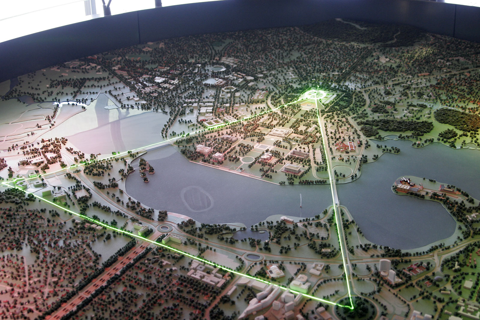
| The Parliamentary Triangle is the ceremonial precinct of Canberra, containing some of Australia's most significant buildings. The triangle is formed by Commonwealth, Kings and Constitution avenues. |
| Russell Offices complex comprise the Office of National Assessments and Australian Security Intelligence Organisation, as well as the Department of Defense and Australian National Defense Force. |
| View of Campbell Park, headquarters of the Australian National Defense Force. |
| The Australian–American Memorial commemorates the role of the United States in World War II. |
Subscribe to:
Comments (Atom)


